Desert Invasion - U.S.Videos of illegal aliens invading the United StatesMost of the following videos taken by concerned American Citizens.
A local Arizona person took this night video of illegal aliens sneaking into the United States. The location is near Sierra Vista, Arizona, a few miles from Roger Barnett's ranch. This is an example of the many groups of illegals sneaking into the US every night.
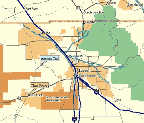
The Amnesty Trail is a corridor that runs north from the Sasabe area on the Arizona/Mexico Border to the area of Three Points and on North. The article, The Amnesty Trail, by Leo Banks was published in The Tucson Weekly. As one of a group of independent citizens who have been trying to get the Border Patrol to interdict the hundreds of aliens pouring through this area each night for over two years to no avail, we have come to the conclusion that the "Amnesty Trail" apparently falls into one of the non-official U.S. Government "designated routes" which are to remain open. A retired USBP agent verifies my suspicions in a recent letter.....
".....As a property owner at the Diamond Bell Ranch sub division, Three Points, we sold our home when prices were up in real estate, and still have some acreage at the Bell. It's beautiful country, a land I've loved since early 1974 when the Los Diablos Cartel controlled the corridor from Sasabe to Three Points. Previously mentioned in USBP discussion.
The east gate was a wire gap in the border fence, an unofficial entry point as well as the west gate. Narcotics, cocaine, marijuana and human trafficking through the area were controlled by the Los Diablos, Nosogra family. For many years the intersection of 86 highway, 286 at Three Points which borders the Tohono O'odam Indian Nation were known as Cocaine Alley, Smuggler's Trails, Death's Hiway and lately the Amnesty Trail. Our small group of agents with assistance from two Arizona State Troopers took back and held the territory for a brief period of time. I might add that local citizens, residents, ranchers, property owners along the corridor were invaluable in providing information to the U.S.B.P. which continued for many years. Their knowledge of what was transpiring in their remote areas led to multitudes of arrests, EWI [Entering Without Inspection] as well as Narcotics interceptions. These routes are correctly pegged the "designated routes" which remain open in a high intensity smuggling area that has not changed since l974. For years prior and since September 11, 2001, the smuggling trails from the Baboquivaries east in the Altar Valley were a point of least resistance. News medias from every quarter have addressed the issue from early 2003 to the present, and most residents, taxpayers on the border are "tired of both political parties" in general. Perhaps basic common sense that is lost in D.C. can be found in Arizona, smuggling trails with discarded passports, airline passes, OTM [Other Than Mexican] lintel that comprise some very interesting entries without inspection. The documentation, trash left behind by illegal alien groups discarded on smuggling entries in the Atar Valley alone measure metric tons. The same holds true on the Tohono Indian Nation. Amnesty Trail is a correct term for Cocaine Alley. If we have not identified and corrected the problem in decades, something is without a doubt amiss. As an Agent, I've worked the territory and also lived in the area which is a beautiful section of Arizona. The smuggling trails by any name in the Three Points area have been dangerous for local residents as well as LEOS spanning twenty years."
The following video was taken by another concerned citizen.
|